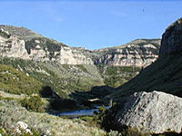
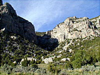
Highway 20 through the Wind River Canyon is the major southern entry into the Big Horn Basin.
The canyon is 12 miles long. Its cliffs rise to hights in excess of 2000 feet.
Prior to the completion of the railroad in 1913 and the highway in
1924, southern access to the Big Horn Basin was extremely difficult.
Jim Bridger scouted a trail to the east over the Owl Creek mountains
near present day Lysite.
In 1803, Lewis and Clark, travelling far to the north and east in
Montana, named the river the Big Horn River. The Crow indians, who
lived near the river's headwaters in the Absaroka mountains, named it
the Wind River. Both names were firmly established before settlers
realized it was one river. The river's name officially changes from the
Wind River to the Big Horn River approximately 1/2 mile from the
northern edge of the canyon. This spot is called "The Wedding of the
Waters."